|
Infrastruktura - Środowisko - Energia
Dodatek lobbingowy do "RZECZPOSPOLITEJ".
20 listopada 2007 r.
po polsku
Can wind be used in Poland as an alternative energy source?
 As recently as the 1980's, when old windmills still scattered throughout Poland were admired as a part of landscape and a relic of history, the Institute for Meteorology and Water Management (IMGW) conducted the first studies on using wind as an alternative source of clean energy that helps to address the impending climate changes provoked also by humans. Since then, restricting emissions of greenhouse gases, mainly carbon dioxide and methane, into the atmosphere became a priority. In order to meet its obligations under the Kyoto Protocol, Poland has to reduce its emissions of greenhouse gases by 20% compared with 1988. As recently as the 1980's, when old windmills still scattered throughout Poland were admired as a part of landscape and a relic of history, the Institute for Meteorology and Water Management (IMGW) conducted the first studies on using wind as an alternative source of clean energy that helps to address the impending climate changes provoked also by humans. Since then, restricting emissions of greenhouse gases, mainly carbon dioxide and methane, into the atmosphere became a priority. In order to meet its obligations under the Kyoto Protocol, Poland has to reduce its emissions of greenhouse gases by 20% compared with 1988.
 The results of studies on the applicability of wind energy in Poland that have been presented in published papers and at academic conferences demonstrate that wind can constitute a source of clean energy in Poland. Certainly this is not true for all regions due to geographic and climatic factors. From the orographic standpoint, Poland is not as flat as Denmark, or Holland, or large parts of California, with their excellent wind conditions. Poland's climate is described as temperate and variable, and its landscape changes from the coastal plain to central lowlands, to high mountains. The results of studies on the applicability of wind energy in Poland that have been presented in published papers and at academic conferences demonstrate that wind can constitute a source of clean energy in Poland. Certainly this is not true for all regions due to geographic and climatic factors. From the orographic standpoint, Poland is not as flat as Denmark, or Holland, or large parts of California, with their excellent wind conditions. Poland's climate is described as temperate and variable, and its landscape changes from the coastal plain to central lowlands, to high mountains.
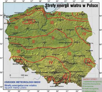
Since the early 1990's, the researchers of the IMGW have conducted detailed studies of wind energy in Poland, both on the regional and the local level. The Institute constantly improves the methods of assessing wind energy ressources, especially on the local level. The well-known and systematically updated authored "Map of wind energy zones in Poland" constitutes a basic source of information that is necessary at the first stage of assessment by potential investors in wind turbines. It is exactly for this reason that it has been made available for purchase from the IMGW and in specialized publications. These are the only two sources where the map is posted as an authored publication. It is regularly updated after each 5-year measurement period and the measurements are a basis for studies on trends and changes in wind structure in a given period. The map constitutes the first credible piece of information that allows investors to determine if using wind for power generation is feasible in the region of their interest. The "Map of wind energy zones in Poland" covers the records of wind speed measurement in the years 1976 - 2005, conducted at the hight of 30 m over the ground surface and in open spaces.
According to the map, on the mezo-scale, the following parts of Poland are "privileged" with respect to wind ressources:
-
the central, most northern parts of the Baltic coast between Koszalin and the Hel peninsula, and the Wolin Island along with the surroundings of the Szczecin Bay,
- the Suwałki region
- central Wielkopolska and Mazowsze,
- the Silesian Beskid and the Żywiec Beskid mountains,
- the Bieszczady Mountains, the Dynowskie Plateau, and the Dukla Pass area,
- the San river valley between the national border and Sandomierz.
The wind energy ressources in the above parts of Poland exceed 1250 kWh/year per 1 m2 of wind turbine propeller surface. Depending on the local terrain conditions this value may increase or occasionally decrease.
There are three stages of assessment of wind energy ressources in a wind turbine or farm location:
Stage 1 - the regional level (mezo-scale) which includes:
-
determination of wind speed (mean: yearly and seasonal) in meters per second at any height between 10 and 90 meters above ground surface,
-
determination of mean yearly and seasonal values of wind energy in kWh/year per 1 m2 of wind turbine propeller surface at the above-mentioned height.
Stage 2 - a visual evaluation of the terrain, performed by the IMGW expert, in order to determine the optimum location of a wind turbine, conducted once Stage 1 of the assessment gives a positive outcome.
Stage 3 - local level information including a detailed evaluation of wind energy ressources for the selected location of the wind turbine, with the use of the WAsP mathematic model developed by the Riso National Laboratory in Denmark, to include:
-
wind energy ressources in W/m2 at the height of 10 - 90 m over the ground surface, according to wind directions;
- yearly production of electric power in MWh for selected types of wind turbines.
The first stage of the assessment is the basic credible approximation that allows for estimating energy ressources on the mezo-scale. The result of this estimation allows for further detailed evaluation of these ressources for any selected location in an area that is privileged with respect to wind energy ressources.
The opinion that the natural conditions in Poland prohibit the usage of wind energy is mistaken and not based on merit. The areas indicated on the Map are conducive to efficient use of wind energy to produce electric power. These areas cover approximately 40% of Poland's territory, assuming that profitability starts at the level of 1250 kWh/m2/year, at the height of 30 m over the ground surface in terrain of roughness class "0 - 1".
The clean, environment - friendly wind energy should be included in Poland's strategic plans.
dr hab. (PhD, assistant professor) Halina Lorenc
a professor at the IMGW
|

